Inventory of USVI Wetlands and Riparian Areas - Phase II
Start Date: June 1, 2009. End Date: May 2, 2010
Project Proponent: Division of Environmental Protection, Department of Planning and Natural Resources
Implementing Agency: University of the Virgin Islands, Conservation Data Center
Principal Investigator: Stevie HenryAn initial effort to address this shortcoming, "The Virgin Islands Wetlands and Riparian Areas Inventory: A Pilot Study to Characterize Watersheds and Wetland Systems, Phase I", was completed in 2004 by the Department of Planning and Natural Resources, in partnership with Island Resources Foundation (IRF) and the University of the Virgin Islands (UVI). The pilot study focused on an: inventory and limited assessment of watershed/wetland ecosystems. Geographic Information System (GIS) technology was used to produce an inventory of watersheds and wetlands (type and location) throughout the Territory, and produce GIS map products as well as data for statistical and spatial analyses. Eighteen (18) priority watersheds (of the 50 throughout the Territory) were assessed and characterized, based on a matrix of undisturbed-moderately disturbed-highly disturbed watersheds. Vegetation characterization, water chemistry sampling, sedimentation history, and an Index of Biological Integrity (IBI) assessment were completed within each selected watershed-wetland complex.
The goal of this Phase II proposal is to complete the preparation of GIS map product visuals of the remaining 32 watersheds (and their corresponding wetland systems and data) for analyses and continued monitoring by resource managers for input in the development and implementation public policies. In addition, total maximum daily load (TMDL) data layers will be combined with watershed characterizations to gain a better understanding of the interplay of multiple stressors.
Contact Information:
Persons and institutions wishing to contribute materials to be reviewed for the project
should contact the Principal Investigator. Materials such as photographs and maps
can also be submitted, and where such materials are used in the final report, credit
will be given to the person or institution that submitted the materials.
The project team will identify priority wetlands for detailed examination during field
assessments and related scientific and technical studies. The field study activities
will include testing protocols and procedures for carrying out these assessments that
are reliable and cost effective in the context of Virgin Islands' wetland conditions.
The project team is seeking your assistance with identifying wetlands we should consider
surveying. Three maps featuring subwatersheds with ghut networks and wetlands are
provided in Adobe GeoPDF format. You will need Adobe Acrobat version 8 or above to view and comment on these maps. To take full advantage of the document
mapping functionality and capabilities you must download the TerraGo -- Geo PDF tool bar.
You can download these documents to your local drive by doing the following:
Right click on the link below and select "Save Link As" if you are using Firefox as
your browser or "Save Target As" if you are using Internet Explorer as browser and
browse to a folder on your local drive.
Based on your knowledge and experience select up to 5 wetland areas per map by marking and explaining briefly why you would focus on these areas. The figure below is a screen shot from the St. Thomas map. Use the following steps to markup and comment on the map:
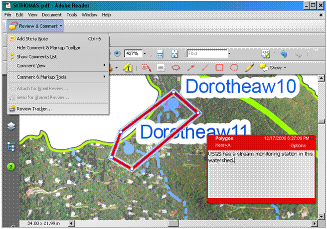
You will save your marking and comments by selecting Export Comments to Data File" option on the [Comment] menu. Attach the data file to an email and send it to shenry@uvi.edu. Contact Stevie Henry 340-693-1033 with any technical question.